Whether you're planning to purchase property, resolve boundary disputes, or simply want to know the exact dimensions of land you own, accurate land measurement is essential. This comprehensive guide explores professional land survey techniques, property area measurement tools, and the most effective methods for achieving precise plot size calculations.
Introduction to Land Surveying
Land surveying is the technique and science of accurately determining the terrestrial or three-dimensional positions of points and the distances and angles between them. These points are usually on the surface of the Earth, and they are often used to establish land maps and boundaries for ownership, building locations, or other government or civil law purposes.
Understanding proper land survey techniques is crucial for various reasons:
- Establishing legal property boundaries
- Determining accurate plot size for valuation
- Planning construction projects
- Resolving property line disputes
- Creating topographic maps
- Supporting land development decisions
For centuries, land measurement has evolved from simple rope and chain measurements to sophisticated GPS technology. Today, both traditional methods and advanced digital tools play important roles in ensuring accurate property dimensions.
Traditional Land Measurement Methods
Tape Measurement
The measuring tape remains one of the most accessible tools for basic land measurement. For small, regular plots with clear boundaries, a long tape measure (typically 100ft/30m) can provide reasonably accurate measurements.
Best practices for tape measurement:
- Use a steel tape for greater accuracy (cloth tapes can stretch)
- Ensure the tape is pulled taut to avoid sagging
- Take multiple measurements for verification
- Account for slope by keeping the tape level
- Use stakes to mark key points during measurement
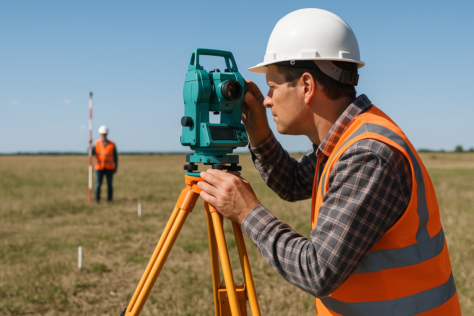
Optical Theodolites
Theodolites are precision instruments for measuring horizontal and vertical angles, a cornerstone of traditional land surveying. They consist of a movable telescope mounted within two perpendicular axes—the horizontal and vertical.
Traditional optical theodolites require skill to operate but provide excellent accuracy for property boundary measurement when used correctly. They work on the principle of triangulation, where angles from known points are measured to calculate distances and positions.
Transit and Level Surveying
Transit surveying involves using a transit (a type of theodolite) to measure horizontal angles, vertical angles, and heights. This traditional method requires:
- Setting up a transit on a known point
- Sighting to a target
- Recording the angle
- Moving to another known point
- Repeating the process to create a network of measurements
Level surveying focuses specifically on determining height differences between points and is crucial for topographic land surveys. This method uses a level instrument to ensure measurements account for the curvature of the Earth.
Modern Digital Land Measurement Tools
Electronic Distance Measurement (EDM)
Electronic Distance Measurement devices have revolutionized land surveying by using electromagnetic waves to determine distances with remarkable precision. These instruments send a signal to a reflector and measure the time taken for the signal to return, calculating distance based on the signal's travel time.
Benefits of EDM for property area measurement include:
- Accuracy within millimeters over long distances
- Faster measurement than traditional methods
- Reduced human error
- Ability to measure difficult terrain
- Digital data recording for later analysis
Total Stations
Total stations combine the capabilities of a theodolite with electronic distance measurement, creating a powerful all-in-one tool for precise plot mapping techniques. Modern total stations offer:
- Electronic angle measurements
- Integrated distance measurement
- Automatic data recording
- Computational capabilities
- Coordinate geometry functions
- Digital interfaces for data transfer
Most professional land surveying services rely on total stations for their efficiency and accuracy in property size verification. These devices allow surveyors to quickly collect data points that can be downloaded directly to surveying software for plot area calculation.
Laser Measurement Tools
Laser distance meters have become increasingly popular for quick land area measurements. While not always suitable for legal boundary surveys, they provide excellent convenience for preliminary estimations and simpler measurement tasks.
Popular types include:
- Handheld laser distance meters (range up to 200m)
- Laser measuring wheels for perimeter measurements
- Rotary laser levels for elevation mapping
GPS Land Survey Techniques
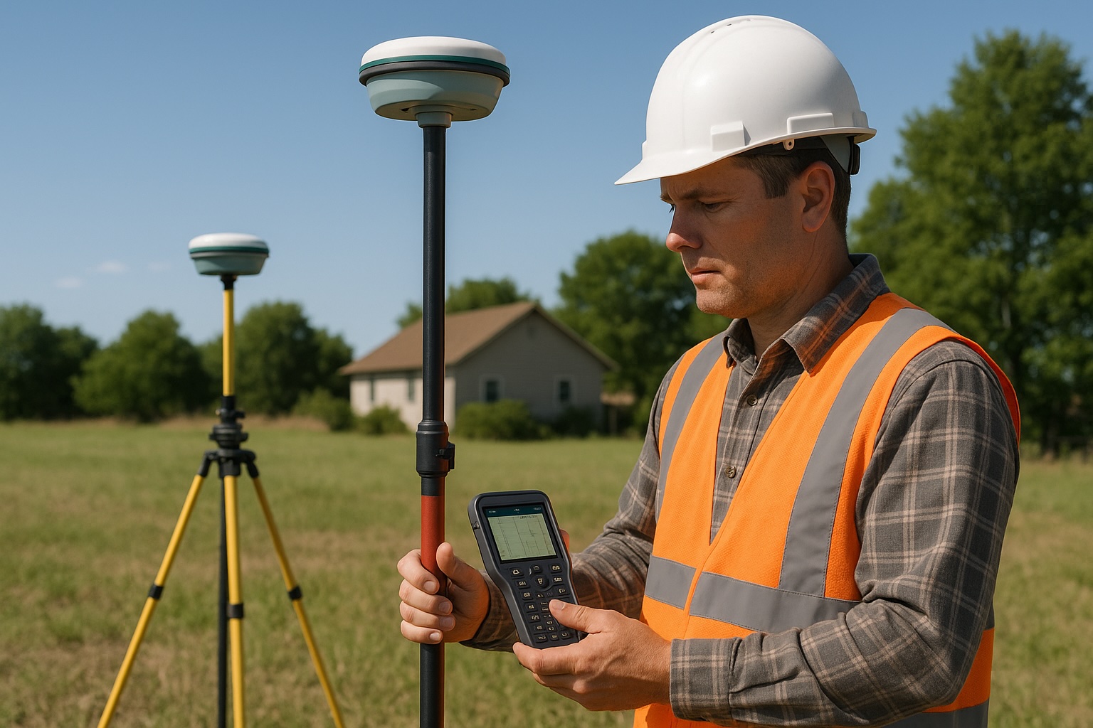
RTK GPS Systems
Real-Time Kinematic (RTK) GPS represents the cutting edge of digital land measurement technology. RTK systems use a base station at a known location and a rover unit that communicates with the base to achieve centimeter-level accuracy.
The advantages of RTK GPS for property boundary measurement include:
- Exceptional accuracy (±1-2 cm)
- No need for direct line of sight between points
- Rapid data collection
- Ability to work in various terrains and conditions
- Integration with mapping software
- Reduced manpower requirements
However, these systems can be expensive and sometimes face challenges in areas with heavy tree cover or tall buildings that block satellite signals.
Differential GPS
Differential GPS (DGPS) is another form of precise GPS land survey that uses a network of fixed ground-based reference stations to broadcast the difference between satellite positions and their known fixed positions.
DGPS improves measurement accuracy by:
- Correcting signal errors
- Providing more stable readings
- Enhancing reliability in varying conditions
- Offering sub-meter accuracy
Mobile GPS Receivers
For preliminary land area estimation or non-legal purposes, even consumer-grade GPS receivers can be useful. While not accurate enough for official property line measurement, handheld GPS units can provide approximate plot dimensions when professional equipment isn't available or necessary.
Surveying Irregular Plots
Breaking Down Into Regular Shapes
One of the most practical methods for measuring acreage accurately, especially for irregular plots, is to divide the land into simpler geometric shapes like triangles, rectangles, and trapezoids.
The process works as follows:
- Sketch the overall shape of the land
- Divide it into manageable geometric sections
- Measure each section independently
- Calculate the area of each section using appropriate formulas
- Sum all section areas for the total plot size
This approach makes land area measurement of complex properties more manageable and often more accurate than attempting to measure the entire perimeter at once.
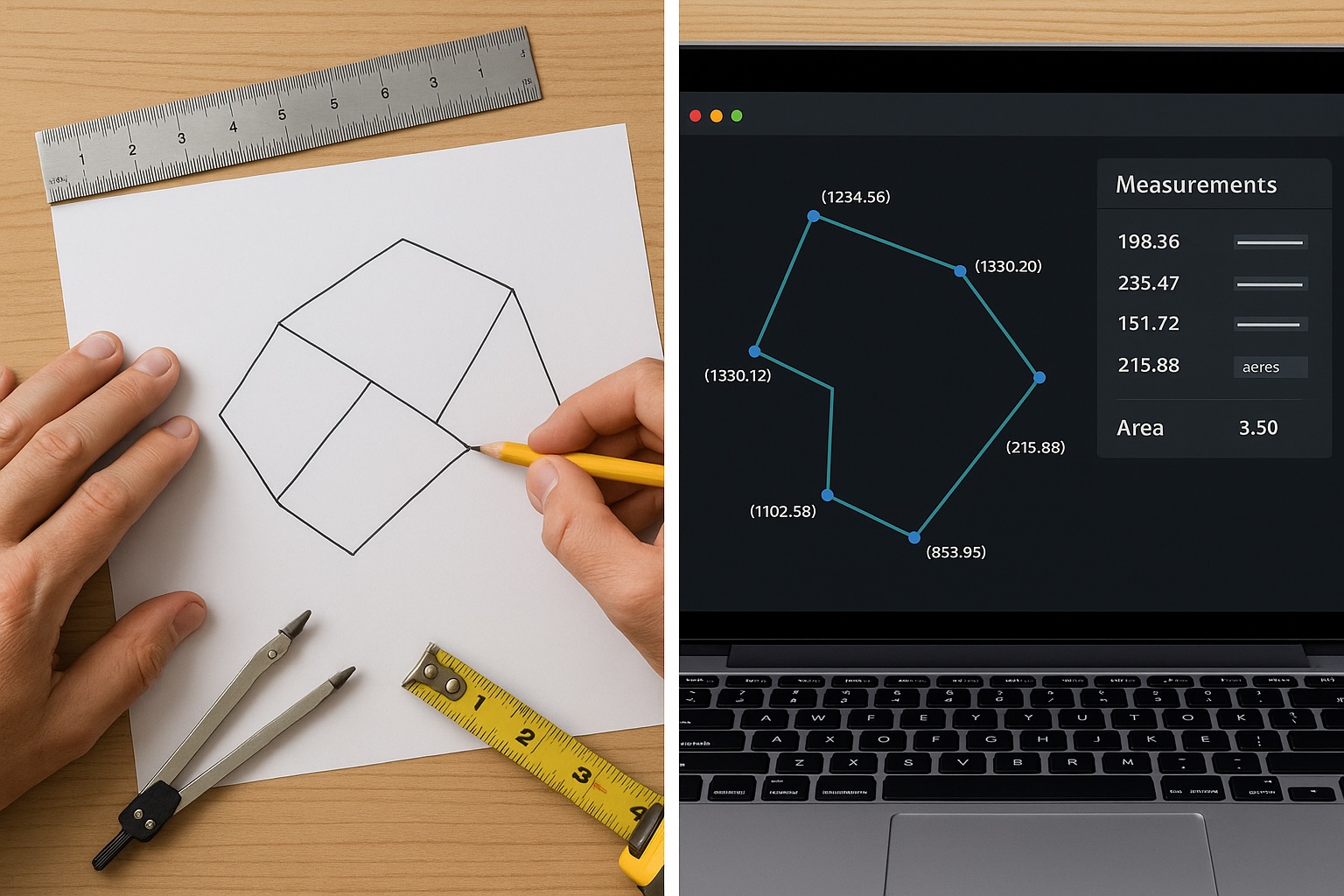
Coordinate Geometry Method
Coordinate geometry (COGO) is a powerful technique for plot area determination when dealing with irregular boundaries. This method involves:
- Establishing a local coordinate system
- Measuring the coordinates of each boundary corner
- Using coordinate geometry to calculate the enclosed area
The formula used is based on the coordinates of each vertex:
Area = 0.5 × |Σ(x₁y₂ - x₂y₁ + x₂y₃ - x₃y₂ + ... + xₙy₁ - x₁yₙ)|
This approach is particularly useful for plot mapping techniques and is commonly implemented in land survey software.
Traversing Method
Traversing is a surveying technique where a series of connected lines with measured lengths and angles are used to establish positions of points. For irregular plots:
- Start at a known point
- Measure the distance and angle to the next point
- Continue the process around the entire boundary
- "Close" the traverse by returning to the starting point
- Check for closure error and adjust if necessary
- Calculate the enclosed area
Professional land surveying often relies on traversing for accurate boundary determination of complex properties.
Plot Area Calculation Methods
Rectangular Coordinates Method
The rectangular coordinates method (also called the double meridian distance method) is one of the most accurate ways to calculate land area from survey data. The process involves:
- Converting field measurements to coordinates
- Organizing coordinates in sequence around the boundary
- Calculating the double meridian distances
- Multiplying each point's Y-coordinate by its double meridian distance
- Summing these products and dividing by 2 for the final area
This method is particularly valuable for property size verification and is commonly used in professional surveying.
Planimeter Method
A planimeter is a specialized instrument designed specifically for measuring the area of an irregular shape on a map or plan. While less common today with the advent of digital tools, it remains an effective method for plot area calculation from existing maps:
- Trace the boundary of the plot with the planimeter
- The device integrates the enclosed area as you trace
- Read the resulting area measurement from the device
Modern digital planimeters have replaced mechanical ones in many applications, offering improved accuracy and digital data recording.
Graphical Methods
When working with maps or aerial imagery, graphical methods can provide reasonable land area estimates:
- Grid counting: Overlaying a grid of known square sizes and counting squares
- Triangulation: Dividing the plot into triangles on the map and summing their areas
- Digital tracing: Using GIS software to trace boundaries and automatically calculate area
Professional vs. DIY Land Measurement
When to Hire Professional Land Surveying Services
While DIY land measurement can be suitable for some situations, professional surveyors should be considered for:
- Legal boundary determination
- Property purchases or sales
- Boundary disputes
- Construction projects
- Subdivision of land
- Easement establishment
- Flood plain determination
Professional surveyors bring several advantages:
- Access to precise geodetic measurement equipment
- Knowledge of legal requirements and standards
- Understanding of historical records and monuments
- Professional liability insurance
- Legal standing of their work
- Experience with complex measurement challenges
DIY Land Measurement Techniques
For preliminary estimates, planning, or non-legal purposes, several DIY approaches can provide reasonable property dimension measurements:
- Rectangular Method: For relatively square/rectangular plots, measure the sides and calculate area as length × width
- Triangulation Method: Divide land into triangles, measure all sides of each triangle, and use Heron's formula to calculate areas
- Online Tools: Use satellite imagery-based tools like Google Earth's measurement feature for rough estimates
- Smartphone Apps: Various land survey apps provide surprisingly good results for basic measurements
Land Measurement Equipment for Homeowners
Budget-friendly tools for DIY land area measurement include:
- Long measuring tapes (100ft/30m)
- Optical distance measurers
- Laser distance meters
- Smart measuring wheels
- Smartphone apps with GPS capability
- Compass for determining bearings
- Stakes and string for marking
Land Survey Apps and Software
Mobile Applications for Land Measurement
The market offers numerous land survey apps that transform smartphones into approximate surveying tools:
- GPS Fields Area Measure: Allows walking or driving around a property to calculate acreage
- Land Calculator: Combines GPS data with manual input for improved accuracy
- Measure Map: Uses satellite imagery to calculate plot areas
- GPS Survey: Records GPS coordinates and calculates enclosed areas
- Field Area Measure: Specializes in agricultural land measurement
While these apps cannot match professional-grade equipment for land survey accuracy, they provide convenient solutions for preliminary assessment and planning.
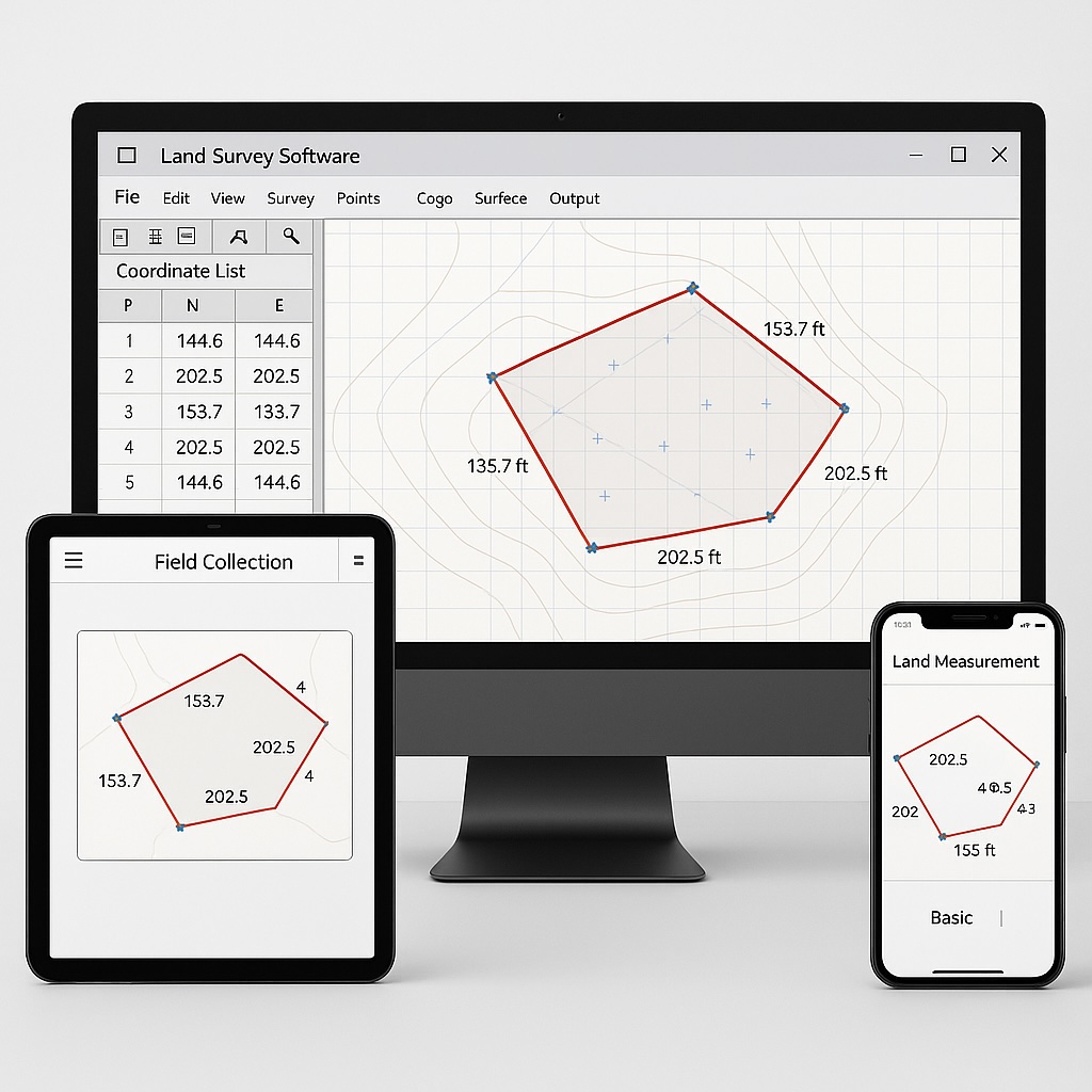
Desktop Survey Software
Professional-grade survey software includes:
- AutoCAD Civil 3D: Comprehensive design and documentation for civil engineering projects
- Carlson Survey: Specialized for land surveyors with powerful COGO capabilities
- MicroSurvey CAD: Combines survey and design tools
- TPC Desktop: Focused on survey data processing and adjustment
- MAGNET Office: Complete field-to-finish survey solution
These programs offer precise plot area calculation, boundary adjustment, and advanced mapping functions.
Cloud-Based Solutions
Modern cloud solutions have transformed land survey data management:
- Leica Infinity: Processes and manages survey data across projects
- Trimble Connect: Collaboration platform for survey data sharing
- Propeller: Specializes in drone data processing for surveys
- LandMentor: Planning and analysis tools for development
- Topcon MAGNET Enterprise: Centralized data management for survey teams
Ensuring Land Survey Accuracy
Common Sources of Error
Even with advanced equipment, several factors can affect land survey accuracy:
- Instrument Errors: Miscalibration or damage to equipment
- User Errors: Improper setup or use of instruments
- Environmental Factors: Temperature, wind, or magnetic interference
- Computational Errors: Mistakes in calculations or data entry
- Reference Errors: Using incorrect benchmarks or control points
Best Practices for Accurate Measurement
To maximize accuracy in property area measurement:
- Calibrate all equipment before use
- Take multiple measurements and average the results
- Check for closure error in traverses
- Verify measurements against known reference points
- Adjust for temperature and other environmental factors
- Use appropriate equipment for the required precision
- Follow standardized measurement procedures
- Document all measurements methodically
Verification Techniques
Several methods can verify the accuracy of land area measurements:
- Redundant Measurements: Take measurements from different control points
- Inverse Calculation: Calculate distances between points from coordinates and compare with measured distances
- Closure Analysis: Ensure traverse closure meets acceptable standards
- Historical Comparison: Compare with previous surveys of the same property
- Cross-Technology Verification: Compare results from different measurement technologies
Legal Considerations in Property Boundary Measurement
Boundary Law Fundamentals
Property boundaries involve both physical measurement and legal principles:
- Boundaries are legally defined by deeds and other documents
- Physical monuments often take precedence over measured distances
- Prior surveys may establish controlling measurements
- Adjoining property rights must be considered
- Water boundaries follow special rules
Documentation Requirements
Proper documentation is crucial for legal standing of property surveys:
- Detailed field notes
- Measurement data and calculations
- References to control points and monuments
- Boundary marker descriptions
- Survey methodology explanation
- Professional certification
- Compliance with state/local requirements
Boundary Disputes
Land measurement often plays a central role in resolving property line disputes:
- Review existing deed descriptions and surveys
- Identify conflicting boundary claims
- Conduct precise measurements using professional equipment
- Establish historical ownership patterns
- Document findings thoroughly
- Consider mediation before litigation
- Present expert testimony if necessary
Accurate land survey techniques are often the key to resolving such conflicts amicably.
Conclusion
Accurate land measurement requires a combination of proper techniques, appropriate tools, and careful methodology. Whether you're using traditional methods like tape measurement and optical transits or embracing modern technologies like GPS land survey equipment and specialized software, understanding the fundamentals of property area measurement remains essential.
For casual purposes and preliminary planning, DIY approaches and land survey apps can provide reasonable estimates. However, for legal matters, property transactions, or construction projects, professional land surveying services offer the precision, legal standing, and expertise necessary for complete confidence in your property dimensions.
By combining traditional knowledge with modern digital land measurement tools, today's property owners and professionals have more options than ever to achieve accurate plot size calculation. The key is selecting the appropriate method and tools for your specific needs while understanding the limitations and advantages of each approach.
Whether you're measuring a residential lot or mapping extensive acreage, the techniques and tools outlined in this guide provide a solid foundation for accurate land measurement in any scenario.
Disclaimer: This guide provides general information about land survey techniques and tools. For legal boundary determinations, property transactions, or other situations requiring legally binding measurements, always consult with a licensed professional land surveyor. For the calculations themselves, our free area calculator handles plots, triangles, and irregular shapes with acre and hectare conversions. For the step-by-step method, read our guide to measuring and calculating land area.